Water Resources Map Services
Maps of pre-packaged sets of data, tasks, and results for use in different applications.
Available Map Services
Current Boil Water Advisories
Public Water Supplies
Water Resources Monitoring Stations
Other Water Resources Data
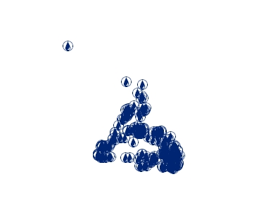 |
Current Boil Water Advisories |
||
| Water supplies currently under Boil Water Advisories. These are issued when water sampling and testing detects higher than accepted amounts of coliforms (bacteria) or if there are deficiencies with regard to chlorination or other forms of disinfection. | |||
| Open Google Link | To view data associated with features, enter the following url as a network link in Google Earth - https://maps.gov.nl.ca/gsdw/services/water/BoilAdvisories/MapServer/KmlServer | ||
| Open ArcGIS Pro Link | URL to Open in ArcGIS Pro - https://maps.gov.nl.ca/gsdw/rest/services/water/BoilAdvisories/MapServer?f=pitemx | ||
| View WMS Capabilities | WMS Map Service Link - https://maps.gov.nl.ca/gsdw/services/water/BoilAdvisories/MapServer/WMSServer | ||
| Open ArcMap Link | URL to Open in ArcMap - https://maps.gov.nl.ca/gsdw/rest/services/water/BoilAdvisories/MapServer?f=lyr&v=9.3 | ||
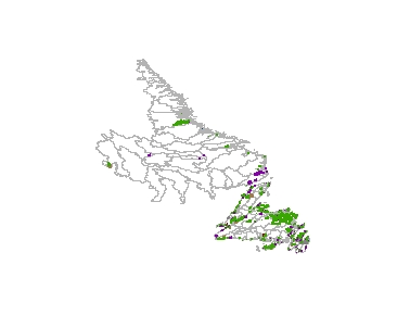 |
Public Water Supplies |
||
| The location of Public Drinking Water Supplies, and related water supply features. This includes watersheds, wellheads and intakes, diversion pipelines, drainage outside protected areas, InterDepartmental Land Use Committee (ILUC) watersheds, and tertiary drainage watersheds. | |||
| Open Google Link | To view data associated with features, enter the following url as a network link in Google Earth - https://maps.gov.nl.ca/gsdw/services/water/WaterSupplies/MapServer/KmlServer | ||
| Open ArcGIS Pro Link | URL to Open in ArcGIS Pro - https://maps.gov.nl.ca/gsdw/rest/services/water/WaterSupplies/MapServer?f=pitemx | ||
| View WMS Capabilities | WMS Map Service Link - https://maps.gov.nl.ca/gsdw/services/water/WaterSupplies/MapServer/WMSServer | ||
| Open ArcMap Link | URL to Open in ArcMap - https://maps.gov.nl.ca/gsdw/rest/services/water/WaterSupplies/MapServer?f=lyr&v=9.3 | ||
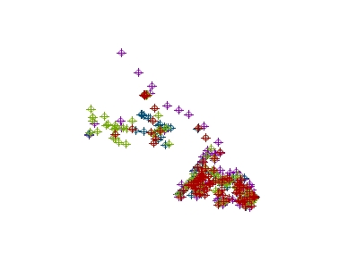 |
Water Resources Monitoring Stations |
||
| Water resources related monitoring stations which includes ambient water quality monitoring stations, hydrometric (stream flow) stations and climate stations. | |||
| Open Google Link | To view data associated with features, enter the following url as a network link in Google Earth - https://maps.gov.nl.ca/gsdw/services/water/Stations/MapServer/KmlServer | ||
| Open ArcGIS Pro Link | URL to Open in ArcGIS Pro - https://maps.gov.nl.ca/gsdw/rest/services/water/Stations/MapServer?f=pitemx | ||
| View WMS Capabilities | WMS Map Service Link - https://maps.gov.nl.ca/gsdw/services/water/Stations/MapServer/WMSServer | ||
| Open ArcMap Link | URL to Open in ArcMap - https://maps.gov.nl.ca/gsdw/rest/services/water/Stations/MapServer?f=lyr&v=9.3 | ||
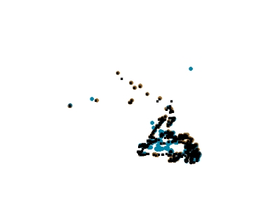 |
Other Water Resources Data |
||
| Other related water resources data including sewage outfalls, dam locations and community locations. | |||
| Open Google Link | To view data associated with features, enter the following url as a network link in Google Earth - https://maps.gov.nl.ca/gsdw/services/water/Infrastructure/MapServer/KmlServer | ||
| Open ArcGIS Pro Link | URL to Open in ArcGIS Pro - https://maps.gov.nl.ca/gsdw/rest/services/water/Infrastructure/MapServer?f=pitemx | ||
| View WMS Capabilities | WMS Map Service Link - https://maps.gov.nl.ca/gsdw/services/water/Infrastructure/MapServer/WMSServer | ||
| Open ArcMap Link | URL to Open in ArcMap - https://maps.gov.nl.ca/gsdw/rest/services/water/Infrastructure/MapServer?f=lyr&v=9.3 | ||